1000+
Projects Annually
Loading...

Our expertise is creating 3D BIM Ready models according to point cloud data (laser scanning) in various softwares (Revit, Archicad, Allplan). Our dedicated team will assist you to implement the benefits of the Scan to BIM process into your company through sharing our knowledge and experience on various Scan to BIM projects in the AEC and MEP industry worldwide.
Licensed softwares in use:


Having adequate and up-to-date 2D designs is a key starting point for all major projects. Since point clouds offer absolutely all information about the appearance of an existing object, it is possible to display all the features, depending on the level of detail. Also, it is possible to realize different projects for the reconstruction and restoration of many buildings based on such plans.
Licensed softwares in use:


Our team uses leading point cloud processing and analysis software and performs registration, post-processing and data analysis services based on all raw point cloud formats. If you have raw laser scan data (or other point cloud capture methods) in any format, our team is ready to deliver a registered and indexed point cloud, in a format suitable for further processing (.rcs, .pts, .e57)
Licensed softwares in use:


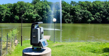
3D laser scanning is a fast and efficient way to collect spatial data, and has proven to be the most efficient way to capture current state. Geobiro Ltd. is one of the leaders in the laser scanning industry in Bosnia and Herzegovina, and the only team specializing in the overall process of "SCAN2BIM"

Geodetic support is of utmost importance in the design and execution of construction works. Surveying experts make the bases for the design, execute the projected structures, supervise the implementation of construction through measuring the dimensions of buildings, control the dimensions of the building after completion of construction, and carry out the measurement of deformations and displacements of already constructed buildings.
Various influences on the built facilities cause their relative displacements in space (most often subsidence). Planning and systematic monitoring of construction is required in order to determine these moves, as part of which we design a geodetic base project from which we notice moves and changes.
The idea of GEOBIRO, headquartered in Konjic at Pleha 2A, has existed and has been in operation since 1991. The main activity of the company includes all activities in the field of geodetic services, and we especially emphasize the services of geodetic engineering for the needs of design and execution of works.
In addition to the conditions that we have fulfilled for the needs of the Certificate for geodetic works performed by independent geodetic entrepreneurs issued by the Federal Geodetic Department, we have the appropriate technical means and equipment to perform geodetic work.
For all the above equipment we have valid certificates issued by the competent institutions, which guarantee the correctness of the surveying equipment.
Thanks to our striving for top quality, many years of experience and constant monitoring of market needs, over the years we have developed into a reputable company whose name becomes a confirmation and guarantee of quality.
Our company employs 90+ qualified geodetic, construction, mechanical and architectural experts